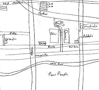
Classroom cognitive mappings of Muncie, Indiana
During the previous semester, thirty students in my urban geography course were asked to use mental maps to explore how students at Ball State University perceive Muncie, Indiana -- a town continually challenged by the effects of deindustrialization.
I've assembled these 155 maps into a video below.
The students effectively used the mental maps to ground their suspicion: that students at Ball State rarely leave the area around campus or the strip of corporate chain shopping and restaurants nearest campus along McGalliard. The morphology of the city was represented with key demarcations between north and south of the White River and the railroad tracks.


If you keep teaching the course / using this assignment, it will be interesting for future students to analyze their own findings w.r.t. your existing archive of mental maps. Also possibilities for assignments to do with maintaining this archive itself: categorizing, for instance, or creating composites ...
ReplyDeleteThe complete assignment was to collect five mental maps and then meet with three other students to compare/contrast all 15 maps. They were to write up the results of this meeting (analysis) and had the option to include a synthesized map (not one group did this part).
ReplyDeleteI think in future iterations, we will collect more mental maps, but only after exploring the existing archive -- to better hone their interpretative skills.